Why Sustainable Farming Needs Better Tools
Sustainable farming is no longer optional for California growers. Rising input costs, tightening environmental regulations, labor shortages, and water constraints are forcing farms to operate more efficiently with fewer resources. Traditional ground-based equipment and broad-acre spraying methods often work against sustainability goals by increasing soil compaction, chemical runoff, and fuel consumption.
This is where Agricultural Drone Services are reshaping modern farming. By combining aerial precision with data-driven decision-making, drones help farmers protect yields while reducing waste and environmental impact.
What Are Agricultural Drone Services?
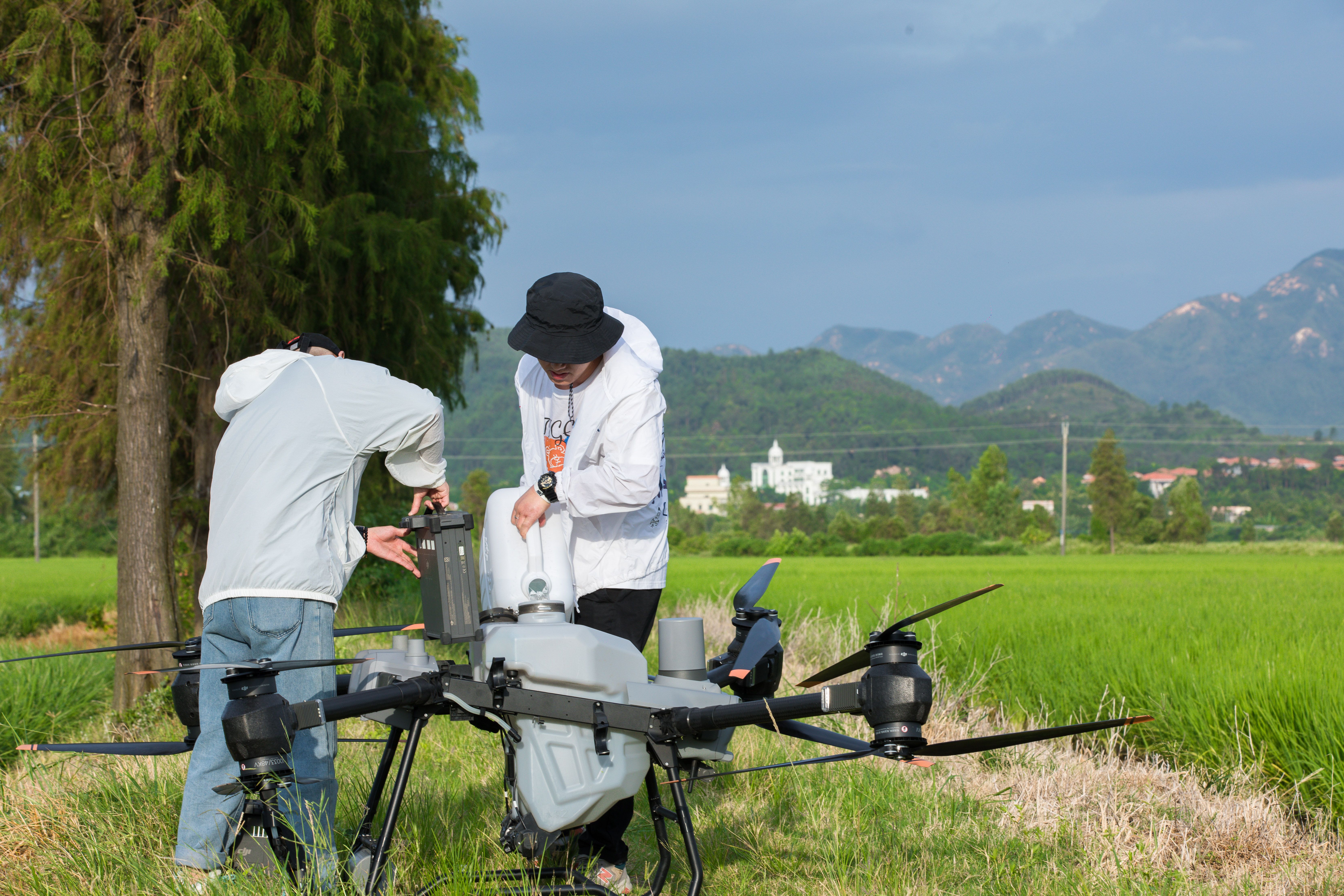
Agricultural Drone Services use purpose-built unmanned aerial systems to apply crop inputs, collect field data, and perform targeted treatments. Unlike hobby drones, these systems are designed for professional agricultural use and operate under strict regulatory standards.
Key capabilities include:
- Precision drone spraying and spreading
- Variable rate application
- Multispectral crop monitoring
- RTK-accurate flight control
- Terrain-following application
To understand the foundation of this approach, review What Is Aerial Application
How Agricultural Drones Reduce Chemical Waste
One of the biggest sustainability challenges in agriculture is chemical overuse. Traditional spraying methods often blanket entire fields regardless of actual crop need, leading to wasted inputs and environmental contamination.
Agricultural Drone Services solve this by delivering inputs only where they are required.
Benefits include
- Reduced pesticide and fertilizer usage
- Lower drift and runoff
- Improved worker safety
- Precise swath width control
- Consistent droplet placement
This shift from volume-based spraying to precision-based application is a major sustainability win.
How to Reduce Pesticide Waste with Drone Mapping
Problem: Over-Application Due to Limited Field Visibility
Many nutrient deficiencies and pest issues are invisible from the ground until damage has already occurred. By that point, farmers often respond with full-field treatments.
Solution: Drone Mapping with Multispectral Sensors
Using NDVI and multispectral imaging, drones identify crop stress early and with pinpoint accuracy. These maps guide variable rate application plans that dramatically reduce chemical waste.
Workflow:
- Multispectral drone survey
- NDVI map generation
- Identification of stress zones
- Targeted drone spraying only where needed
Research from the bold University of California Agriculture and Natural Resources Extension supports targeted application as a key strategy for reducing pesticide waste.
Precision Application in California Farming Regions
California’s diverse agricultural regions demand flexibility and accuracy.
Examples of regional use
- Drone crop spraying in Kern County for wheat and almonds
- Vineyard spot treatments in Riverside and San Diego counties
- Orchard spraying in Ventura County
- Cover crop seeding across Central Valley row crops
For statewide service context, see Agricultural Drone Services in California
Case Study: Drone Crop Spraying in Kern County
Mission Overview
- Crop: Wheat
- Area: 200 acres
- Location: Kern County, California
Objective
Reduce nitrogen waste and improve crop uniformity.
Execution
- Conducted RTK-accurate multispectral survey
- Generated NDVI maps highlighting nitrogen deficiency
- Designed variable rate application map
- Performed targeted drone spraying
Results
- Identified nitrogen deficiency in 200 acres of wheat
- Reduced nitrogen usage by 22 percent
- Improved crop consistency within two weeks
- Eliminated ground equipment passes
First-hand proof includes original mission photos of drones in flight, landing gear inspections, and NDVI outputs archived internally.
Technology Powering Modern Agricultural Drone Services
Professional agricultural drones are engineered platforms, not consumer devices.
Key technologies include:
- RTK precision for centimeter-level accuracy
- Adjustable swath width for uniform coverage
- Variable rate application controllers
- Terrain-following radar
- Redundant flight safety systems
Hardware comparisons should be reviewed annually as platforms evolve. Current-generation systems such as the DJI Agras T50 outperform older models in payload capacity, battery efficiency, and spray consistency.
Safety, Compliance, and Chemical Handling Standards
Sustainable farming also means responsible operations.
Professional Agricultural Drone Services follow strict safety and compliance protocols:
- FAA Part 107 licensed pilots
https://www.faa.gov/uas/commercial_operators/part_107 - State agricultural chemical handling certifications
- Pre-flight risk assessments
- Controlled chemical mixing and loading
- Documented flight logs and maintenance records
Author credentials include FAA Part 107 certification and extensive agricultural flight hours. Learn more about pilot qualifications on the About Specialty Drone Solutions page.
Why Agricultural Drone Services Support Long-Term Sustainability
Sustainability is not just environmental. It is economic and operational.
Key sustainability outcomes:
- Lower fuel consumption
- Reduced soil compaction
- Fewer chemical inputs
- Improved regulatory compliance
- Better long-term soil health
By replacing heavy equipment and manned aircraft with battery-powered drones, farms significantly reduce their environmental footprint while improving profitability.
Frequently Asked Questions
Are agricultural drones environmentally friendly?
Yes. Precision application reduces chemical use, runoff, and fuel consumption.
Are drone spraying services legal in California?
Yes, when operated by licensed pilots in compliance with FAA and state regulations.
Can drones replace traditional spraying equipment?
Drones complement and often outperform traditional methods, especially for targeted and sensitive applications.
Next Steps for Growers
If you are evaluating Agricultural Drone Services for sustainable farming, the next step is assessment.